


Paradise Walk
Cover Image: “Pilgrims leaving Canterbury” from the Troy Book and the Siege of Thebes by John Lydgate (c. 1520); illustrated by Lucas Horenbout.
Chaucer never completed Canterbury Tales, abandoning his pilgrims before they reached their destination at the shrine of St. Thomas Becket. John Lydgate, a monk from Bury St. Edmunds, took up the story, interjecting himself into the narrative, and adding new tales to the collection. Sometime around 1520, this manuscript on vellum was prepared of his story “The Seige of Thebes,” and was illustrated by a Flemish painter, Lucas Horenbout. (You can read the whole of Lydgate’s story by following this link.)
The manuscript is in the British Library, MS Royal 18 D II f. 148.
The Wandering Heart
Cover Image: The Meeting on the Turret Stairs, Frederic William Burton (1864)
Though The Meeting on the Turret Stairs depicts a medieval woman and her Crusader knight, it was not painted until 1864, when romanticized medieval subjects were popular among the pre-Raphaelite artists. The painter, Frederic William Burton, was born in Corifin, County Clare, but lived in England for many decades. He was Director of the National Gallery in London for twenty years, and was influenced by Dante Gabriel Rossetti and his pre-Raphaelite Brotherhood, though he never actually became a member of the group. The painting is in the collection of the National Gallery of Ireland, Dublin.
Visit the National Gallery of Ireland website.
For more on the story behind the painting, visit the website of the Clare County Library.


Souvenirs of the Fur Trade: Northwest Coast Indian Art and Artifacts Collected by American Mariners
Cover Image: Haida Mask (ca. 1825)
This is one of a number of masks created by a Haida master carver in the early 19 th century, several of which were collected by American sailors trading on the Northwest Coast. Captain Daniel Cross collected one on a voyage of the Boston ship Rob Roy, which he gave in 1827 to the museum of the Salem East India Marine Society (now the Peabody Essex Museum). This example, at the Peabody Museum of Archaeology and Ethnology at Harvard, was originally donated to the American Antiquarian Society in Worcester, MA, around 1826, and transferred to the Peabody in 1948.
"Boston Men" on the Northwest Coast: The American Maritime Fur Trade, 1788-1844
Endpapers: Map of the Northwest Coast (179X with additions in 184X and 199X)
This map of American Trade on the Northwest Coast is derived from the copy of Captain George Vancouver's 1794 "Chart shewing part of the Coast of N.W. America" that was used from 1825 to 1828 aboard the Boston brig Griffin. This chart is in the collection of the Sturgis Library in Barnstable, Massachusetts, which is located in William Sturgis's home. In 1998 Mary Malloy and Erik Zettler of the Sea Education Association in Woods Hole, MA added to it the places described by American mariners in their shipboard logs.


Devil on the Deep Blue Sea: The Notorious Career of Captain Samuel Hill of Boston
Cover Image: The Ship Franklin of Salem, MA in Batavia (ca. 1790)
This is the only painting that survives of any vessel on which Samuel Hill served. It was painted in the Dutch East Indies, probably when the Franklin was there making preparations for the voyage to Japan in 1790.
Collection of the Peabody Essex Museum, Salem, Massachusetts (M11,925).
Visit the Peabody Essex Museum website.
The Wonder Chamber
Background cover image: This is the “Wunderkammer” or “Wonder Chamber” of the Neapolitan apothecary Ferrante Imperato, engraved in his book Dell'Historia Naturale of 1599. The collection was displayed at the Palazzo Gravina in Naples.
This image, and one of the cabinet of curiosities of Ferdinando Cospi (1606-1686), inspired the description in The Wonder Chamber of the Gonzaga family collection, and especially of the drawing that Lizzie found of it.
A Most Remarkable Enterprise: Lectures on the Northwest Coast Trade and Northwest Coast Indian Life by Captain William Sturgis
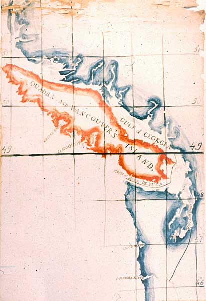
Cover Image: Map of the Northwest Coast by William Sturgis (ca. 1845)
William Sturgis gave a lecture in January 1845 at the Mercantile Library Association in Boston on "The Oregon Question." In the lecture he discussed the negotiations then ongoing between the American and British governments to determine the border between the two countries to the Pacific Coast. Though American interests had called for a border as far north as 54° 40' (the southern border of the Russian claims), and British claims were made as far south as the Columbia River, moderate interests were beginning to discuss a settlement at 49' North Latitude. Sturgis, a man with significant experience on the Northwest Coast, did not think the British would accept a straight 49° border as it would cut off their access to the straights of Juan de Fuca. Sturgis suggested the border that was finally accepted, and he painted it on this map, probably to illustrate his lecture.
The map is in the collection of the Peabody Essex Museum.

Mary took this photograph of the castle ruin near the Clonmacnoise monastic site in September, 2017.